| |
In March of 1924, a report was submitted to the governor of Maryland by the Public Service Commision in conjunction with the State Roads Commision, proposing a State owned ferry.3 The report documented the various ferry services operating at the time, several of which recieved State subsidy, but none of which were owned by the State outright. There was one between Annapolis and Claiborne, it was a long two hour ride each way, another ran between Bay Shore and Rock Hall, which is some 10 miles north of the western end of the Bay Bridge. At some point, only briefly, there had been a ferry running between Baltimore and Love Point, the northern most tip of Kent Island. |
|
The report also outlined the drawbacks of the private ferry services. Several of the companies had gone bankrupt. There had never been a company who operated enough boats to make the wait reasonable. But biggest drawback was the cost; $2.50 to $5.00 to cross with your car! Today it costs $2.50 to cross the bay and back, imagine how that felt in 1924!
Since the turn of the Century, Baltimore businessmen had watched their Eastern Shore trade, which had previously come by boat, travel instead to Wilmington or Philidelphia by train and highway.
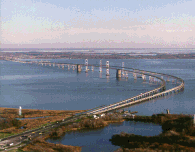
So, choosing the shortest possible distance for a route, it was proposed that the State ferry run from Sandy Point on the west, to Stevensville on Kent Island, exactly where the bridge now stands. |